
Mine surveying provides the spatial foundation for every engineering activity at a mining operation. Every decision - from mine planning to production reporting - depends on accurate data describing the geometry of mining works. Where does the ore body boundary lie? How closely does the actual pit wall match the design? How much material has been mined this month, and does it align with the plan? All of these questions depend on survey data.
The cost of survey errors is significant. A mid-sized open-pit operation with a 10,000-tonne discrepancy in stockpile volume assessment can face an annual variance of $60,000–70,000. After implementing more accurate measurement methods, many operations discover an additional $100,000 or more in material that was previously unaccounted for. A missed deviation from the designed pit wall position can become a geotechnical hazard, while inadequate monitoring of licence boundaries can create regulatory risk.
Historically, mine surveying was a periodic activity: survey crews visited the site once a month, collected measurements manually, and delivered plans days later after processing. Today, mining operations require a near-real-time understanding of conditions - not from last month, but from last week or even yesterday. This demand for faster data delivery has become the primary driver of survey digitalization.
This article examines three key spatial data collection methods - conventional geodesy, UAV photogrammetry, and LiDAR laser scanning - compares their strengths and limitations for open-pit mining applications, and demonstrates how the K-MINE Surveying Module integrates data from all sources within a single mining environment.
Conventional Survey Methods: Reliable but Limited
Total stations and GNSS surveying remain the foundation of mine survey practice. A total station can achieve accuracy of ±2–5 mm, while RTK GNSS typically provides ±10–20 mm accuracy in plan and elevation. These methods are well understood, easily verified, and require minimal post-processing.
For layout work, survey control, blasthole positioning, and geodetic control networks, there is still no practical replacement for total stations and GNSS systems.
However, traditional methods have inherent limitations that become increasingly significant as mines expand and survey frequency requirements increase.
Surveying a 1–2 km² pit can require several shifts, while point density remains relatively low. Because surveyors cannot physically measure every square metre, interpolation between survey points is unavoidable, introducing potential errors into volume calculations. On complex terrain, these errors can accumulate and create substantial discrepancies.
Safety is another concern. Ground-based surveys require personnel to enter active mining areas, including working benches, highwall crests, drilling zones, and loading areas. This often creates operational conflicts and may require temporary work interruptions.
In addition, monthly terrain model updates - still common at smaller operations - are often too infrequent for modern production accounting and geotechnical monitoring requirements.
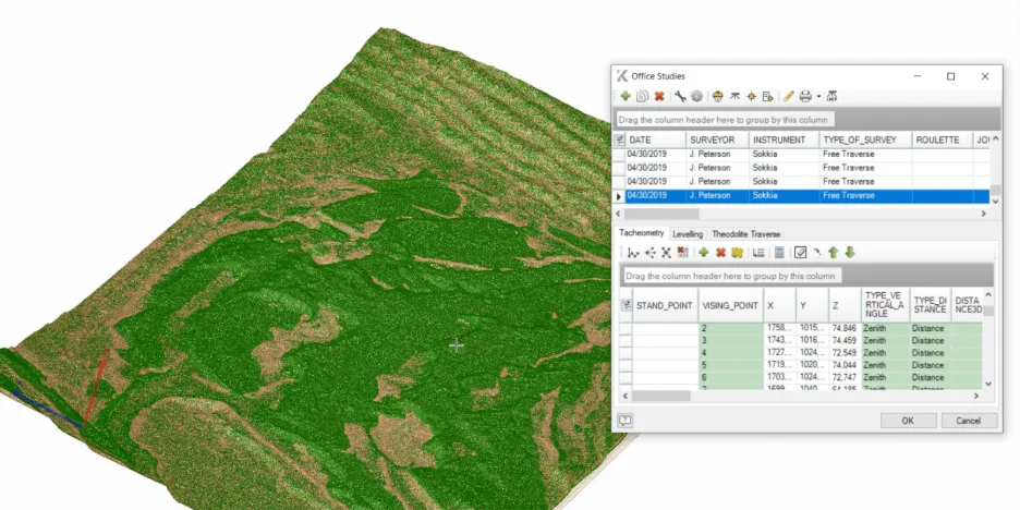
Within K-MINE, total station and GNSS data are managed through the Office Studies module. This centralized survey database maintains complete traceability, recording the operator, instrument, date, and measurement method associated with every observation.
K-MINE supports native data formats from Leica, Sokkia, Trimble, Topcon, and Nikon instruments, eliminating the need for intermediate conversion. CSV and TXT formats with custom field structures are also supported.
For example, after surveying three free stations with a Leica total station, an engineer can import the GSI file directly into Office Studies. K-MINE automatically recognizes the file structure, calculates survey point coordinates, and stores the results together with instrument and operator metadata. Those points are then immediately available for DTM updates and surface generation.
UAV Surveying: Complete Pit Coverage in a Single Flight
Unmanned Aerial Vehicles (UAVs) have transformed mine surveying by dramatically improving both speed and efficiency.
A multirotor or fixed-wing drone can complete an autonomous flight within one to two hours, capturing overlapping high-resolution imagery across several square kilometres. Using Structure-from-Motion (SfM) processing, the imagery is converted into dense point clouds, orthophotos, and Digital Terrain Models (DTMs).
Research and operational experience consistently demonstrate that properly planned UAV surveys can achieve accuracy levels suitable for most mining applications while significantly reducing field time and cost.
Typical UAV photogrammetry accuracy ranges from ±30–50 mm. When supported by RTK/PPK positioning and ground control points (GCPs), accuracy approaches the lower end of this range.
For volume calculations, stockpile monitoring, and operational tracking, this level of accuracy is more than sufficient.
Compared with conventional surveying costs of approximately $500–1,500 per hectare, UAV surveys typically cost $150–300 per hectare while reducing field labour by 60–80%. Survey frequency often increases four- to five-fold without increasing overall cost.
K-MINE imports UAV-derived point clouds generated by Agisoft Metashape, Pix4D, DJI Terra, and similar platforms using the Import Point Cloud function.
Supported formats include: LAS, LAZ, CSV, TXT, XYZ.
Point clouds are displayed directly within K-MINE’s 3D environment using adjustable Level of Detail (LOD) settings, enabling efficient handling of datasets containing hundreds of millions of points.
Recommended point densities include:
- 5–20 points/m² for volume calculations
- 50–100+ points/m² for geotechnical analysis
Because photogrammetry relies on image matching, noise can occur along flight boundaries, shadowed areas, and low-texture surfaces.
K-MINE provides two dedicated cleanup tools:
Statistical Outlier Removal (SOR)
SOR evaluates the average distance between each point and its neighbours, automatically identifying statistical outliers. Rather than permanently deleting points, the tool hides them, allowing fully reversible processing.
Noise Filtering
Noise Filtering provides more advanced control through:
- Radius- or count-based neighbourhood searches
- Relative or absolute deviation thresholds
- Removal of isolated points
Cleaned datasets can then be exported using the Save Visible Points function, with optional decimation to reduce file size while preserving geometric integrity.
Surface Reconstruction
After cleaning, surface generation begins.
Calculate Normals computes surface normals for each point by fitting a local least-squares plane.
These normals are required for:
- Accurate shaded visualization
- Surface reconstruction workflows
Poisson Wireframe then creates a closed triangulated mesh using adaptive octree processing. Reconstruction levels of 10–12 generally provide the best balance between accuracy and performance, while levels above 13 maximize detail for critical engineering applications.
The resulting mesh can be used directly for volume calculations and design analysis.
UAV Limitations
Despite their advantages, UAV surveys remain weather dependent.
Performance can be degraded by:
- Dense fog
- Snowfall
- Strong winds
- Poor lighting conditions
Photogrammetry also reconstructs only visible surfaces. Areas hidden by shadows, steep geometry, or equipment may contain gaps or increased noise.
LiDAR: When Accuracy and Reliability Are Critical
LiDAR (Light Detection and Ranging) operates on a fundamentally different principle.
Instead of relying on imagery, LiDAR systems emit laser pulses and calculate distances based on pulse return times. This approach is independent of lighting conditions, surface colour, and texture.
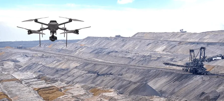
Airborne LiDAR systems mounted on drones or helicopters commonly produce point cloud densities ranging from 50 to 500 points/m², with accuracy of ±2–5 mm.
Terrestrial Laser Scanners (TLS) provide even more detailed measurements of benches, slopes, and infrastructure.
Repeated TLS surveys can detect ground movements as small as 5–10 mm, providing early warning of potential slope instability.
LiDAR performs effectively:
- At night
- In dusty environments
- Under poor lighting conditions
These are precisely the situations where photogrammetry often struggles.
Although LiDAR surveys typically cost $400–800 per hectare, the additional accuracy and reliability justify the expense for geotechnical monitoring and high-precision engineering applications.
Terrain Classification
One of the most important LiDAR processing steps is separating terrain from non-ground objects.
K-MINE performs this using the Terrain Filter based on the Cloth Simulation Filter (CSF) algorithm.
The process simulates a virtual cloth draping over an inverted point cloud. Points close to the cloth are classified as terrain, while remaining points are classified as vegetation, equipment, or structures.
Steep Slope mode is particularly valuable for open-pit mines because it preserves sharp bench and highwall geometry.
Advanced Analysis
Following classification, Calculate Normals can be used to evaluate local slope angles and identify areas that deviate from design parameters.
The Set Point Cloud Colour function allows visualization based on:
- Elevation (Z)
- Laser intensity
Intensity visualization is unique to LiDAR datasets and often provides valuable additional insight.
K-MINE also includes Cloud-to-Cloud Distance analysis, which calculates deviations between successive surveys and displays results as colour-coded maps highlighting:
- Excavation zones
- Fill zones
- Stable areas
Results can be transferred directly to K-MINE geotechnical and slope stability workflows.
Choosing the Right Survey Method
No survey method is universally optimal. Each technology excels in specific applications.
| Criteria | Total Station / GNSS | UAV Photogrammetry | LiDAR |
|---|---|---|---|
| Accuracy | ±2–5 mm / ±10–20 mm | ±30–50 mm | ±2–5 mm |
| Coverage per shift | 0.1–0.3 km² | 2–10 km² | 2–15 km² |
| Point density | Low | High | Very High |
| Weather dependency | Low | High | Moderate |
| Work zone access required | Yes | No | No |
| Typical cost | $500–1,500/ha | $150–300/ha | $400–800/ha |
| Best applications | Layout, control, drilling | Volumes, DTM updates, monitoring | Geotechnics, deformation monitoring |
Most open-pit operations benefit from a combined approach:
- Total stations and GNSS for precision control and layout
- UAV surveys for routine DTM updates and volume calculations
- LiDAR for geotechnical investigations and difficult operating conditions
Survey frequency can be estimated using:
Allowable Volume Error ÷ Average Extraction Rate
For example, if a mine extracts 50,000 m³ per month and allows a maximum error of 5,000 m³, surveys should occur approximately every two days.
The key advantage of K-MINE is that all survey data - whether from LAS, LAZ, CSV, DXF, DWG, Leica, Sokkia, Trimble, Topcon, or Nikon formats - is managed within a single integrated environment.
Volume Calculations and Monitoring
Volume calculation is where survey accuracy most directly influences financial performance.
Large mining operations move millions of cubic metres annually. Even a 1% calculation error can result in major reporting discrepancies.
K-MINE provides three primary volume calculation methods:
Surface-to-Surface
Compares two triangulated surfaces and calculates elevation differences throughout the model.
Closed Solid
Calculates volume within closed wireframes or meshes, including Poisson-generated solids.
Block Model-Based Calculation
Integrates block model attributes, allowing calculations that incorporate grade, density, and other geological parameters.
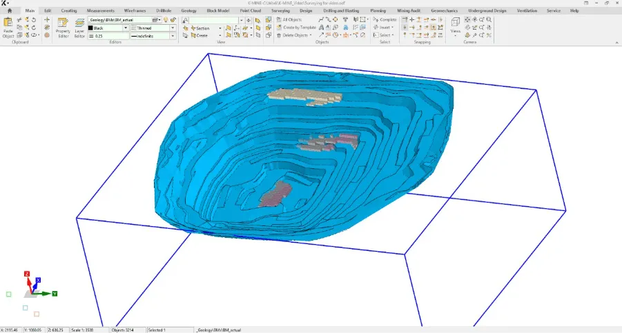
For operational monitoring, K-MINE generates colour-coded deviation maps comparing design and actual surfaces.
These maps immediately highlight:
- Under-excavation
- Over-excavation
- Pit wall deviations
Configurable alerts automatically identify critical departures from design parameters.
Survey reports can be generated from built-in templates, while design coordinates-including blastholes and survey control points-can be exported directly to field GPS devices, eliminating manual transcription errors.
Conclusion
UAVs and LiDAR do not replace total stations - they extend the capabilities of modern mine surveying.
The optimal technology depends on project objectives, required accuracy, operating conditions, and survey economics.
However, collecting data is only the beginning. Modern mining operations must integrate information from multiple sources, formats, and accuracy levels into a unified environment that supports geology, mine planning, production control, and reporting.
This integration challenge - not data acquisition itself - has become the true bottleneck of digital mine surveying.
Mining companies that recognize this are no longer searching for isolated tools. They are looking for a connected environment where survey data flows seamlessly into every stage of the mining workflow.
That is where integrated platforms such as K-MINE deliver their greatest value.

