
Exploration Data Looks Structured Until the Project Starts Moving
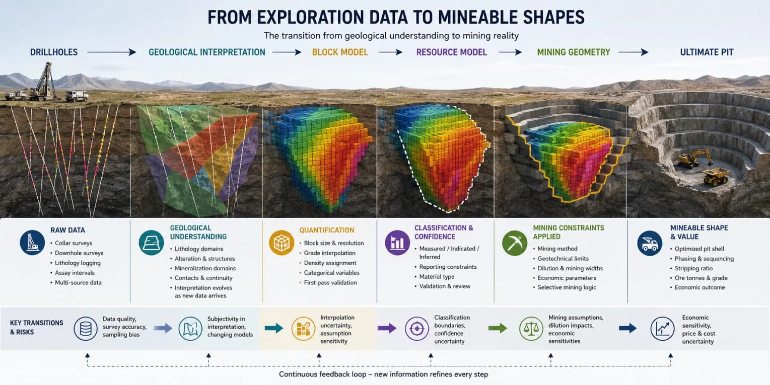
At the early exploration stage, most mining datasets appear manageable. Drillholes are being completed, assays are arriving regularly, interpretations are evolving, and the technical team still has a relatively clear understanding of where the information came from and how it was generated. The problem is that exploration workflows are usually optimized for discovery speed, not long-term project continuity, and that distinction matters far more than many teams realize.
As projects grow, geological data rarely enters the system through a single clean and stable process. Different drilling campaigns may involve different contractors, logging standards, sampling intervals, survey methods, coordinate systems, and coding conventions. Geological interpretations evolve as new information becomes available, domain boundaries shift, density relationships are refined, weathering profiles become more detailed, and sometimes even the fundamental lithological logic changes between campaigns. None of this is unusual. It is simply how exploration works.
The issue is that these inconsistencies often remain invisible while the project is still focused primarily on defining mineralization and expanding resources. At that stage, workflows only need to support geological interpretation and exploration targeting, so as long as new drilling continues reinforcing the overall exploration narrative, the system appears functional enough.
When Study Work Begins, the Cracks Show
The situation changes once the project begins moving toward resource estimation and engineering studies. The same information is suddenly expected to support mine design, scheduling, processing assumptions, geotechnical analysis, infrastructure planning, economic modeling, and eventually reserve declaration. Data that previously existed mainly to help geologists understand the deposit must now behave consistently across multiple technical disciplines that depend on traceability, repeatability, and stable assumptions.
This is usually where the first serious disconnect appears.
A geological database that worked adequately during exploration may still contain inconsistent coding, overlapping naming conventions, incomplete validation history, manually corrected intervals, or interpretation logic that exists only in the heads of specific geologists. During exploration, experienced team members can often navigate around these issues informally because the technical group remains relatively small and closely connected. During study work, informal understanding no longer scales. The project begins relying less on people remembering context and more on systems being capable of preserving it.
Exploration Data Rarely Fails All at Once
That transition exposes a reality many mining teams encounter much later than they should: exploration data is rarely lost through one major technical failure. More often, it degrades gradually through interpretation changes, spreadsheet corrections, disconnected databases, duplicated exports, inconsistent assumptions, and manual transfers between departments. Once those inconsistencies enter the resource model, they become significantly harder to isolate because they begin propagating downstream into engineering decisions.
A modified domain boundary may affect tonnes and grade distribution in ways that become difficult to trace months later. A survey correction can subtly shift ore contacts, mining shapes, and local stripping ratios. A density assumption introduced early during exploration may survive deep into feasibility work long after the geological understanding behind it has evolved.
By the time a project reaches the PFS or DFS stage, teams are often working with datasets that technically originated from the same drilling campaigns but operationally behave like several partially disconnected versions of the orebody. At that point, a surprising amount of engineering effort stops going into improving the mine plan itself and starts going into rebuilding confidence in the information chain behind it.
The Resource Model Is Usually the First Major Disconnect
Once exploration data moves into resource estimation, many projects assume the workflow is becoming more controlled and technically mature. In some ways, that is true. Databases are cleaned, validation improves, geological interpretations become more formalized, and estimation methodologies undergo more rigorous review. The project begins producing outputs that appear stable enough for reporting, study work, and investor communication.
At the same time, however, the resource model often becomes the first place where geological understanding starts separating from mining reality.
Estimation and Mining Solve Different Problems
Part of the problem is structural. Resource estimation and mine planning solve related but fundamentally different technical problems. Resource geology focuses on representing the orebody as accurately and defensibly as possible within the limits of available data. Mine planning focuses on extraction practicality, operational selectivity, dilution behavior, sequencing logic, equipment constraints, and economic performance over time.
A model can therefore be technically robust from an estimation perspective while still creating friction everywhere downstream.
This happens more often than many teams admit. Domains that work well for interpolation may be awkward for practical mining selectivity. Grade continuity may appear reasonable at block scale while still producing unstable ore-waste boundaries once mining widths and dilution are introduced. Geological contacts may be interpreted correctly but generate shapes that are too irregular for efficient phase design or practical scheduling logic.
None of this means the resource model is wrong. It simply means the transition from “geologically representative” to “mineable and schedulable” is never as smooth as project workflows pretend it is.
The disconnect becomes even more visible once planning teams begin simplifying the model for downstream use. Sub-blocking may be reduced to improve performance. Certain geological attributes disappear during exports. Local estimation complexity gets averaged into broader mining units. Variables that mattered during resource estimation suddenly become difficult to preserve consistently through pit optimization, phase generation, scheduling, and production forecasting.
At that point, the model may still look complete inside the software, but parts of the geological context have already started disappearing.
This is especially dangerous in deposits with strong local variability. Narrow-vein gold systems, lithium pegmatites, layered industrial mineral deposits, and structurally controlled orebodies are often highly sensitive to small changes in dilution, mining width, recovery behavior, and grade continuity. A relatively modest adjustment inside the resource model can produce disproportionately large downstream consequences once real mining geometry is introduced.
For example, smoothing during estimation may not create major reporting issues on paper, yet later reduce the planner’s ability to separate ore from waste effectively at bench scale. A geological domain that appears internally consistent during estimation may still behave poorly during phase development because ore exposure becomes unstable across mining periods. A density relationship considered acceptable during MRE work may later distort material movement forecasts once production schedules are built.
These are not edge cases. They are exactly the disconnects that quietly push planning teams into manual reconciliation work later in the project.
Talvivaara in Finland serves as a useful reminder of how expensive this can become. The nickel project was praised early for the size of its reserves, but the deposit proved geologically and metallurgically more complex than the resource model suggested, and the recoverable behavior of the ore was never fully captured upstream. Despite encouraging feasibility work, the operation ran into severe technical and financial difficulties and entered bankruptcy in 2014. The deposit itself never changed between the study phase and operations. The understanding of it simply failed to travel intact from geology into processing and economics.
Hidden Assumptions Travel Downstream
Another issue is that resource models often contain numerous embedded assumptions that become progressively less visible outside the geology team. Search strategies, compositing logic, capping approaches, domain boundaries, variography decisions, classification methodology, density treatment, and interpolation parameters all influence final model behavior. Yet once the block model is handed downstream, many of those assumptions become partially hidden behind the numbers themselves.
Planning engineers and schedulers inherit tonnes, grades, and codes, but not always the complete technical context explaining how stable or sensitive those values actually are.
This creates a subtle but important risk. The further the project advances into engineering studies, the more likely teams are to treat the resource model as fixed truth rather than as a technically interpreted dataset carrying uncertainty, limitations, and operational consequences.
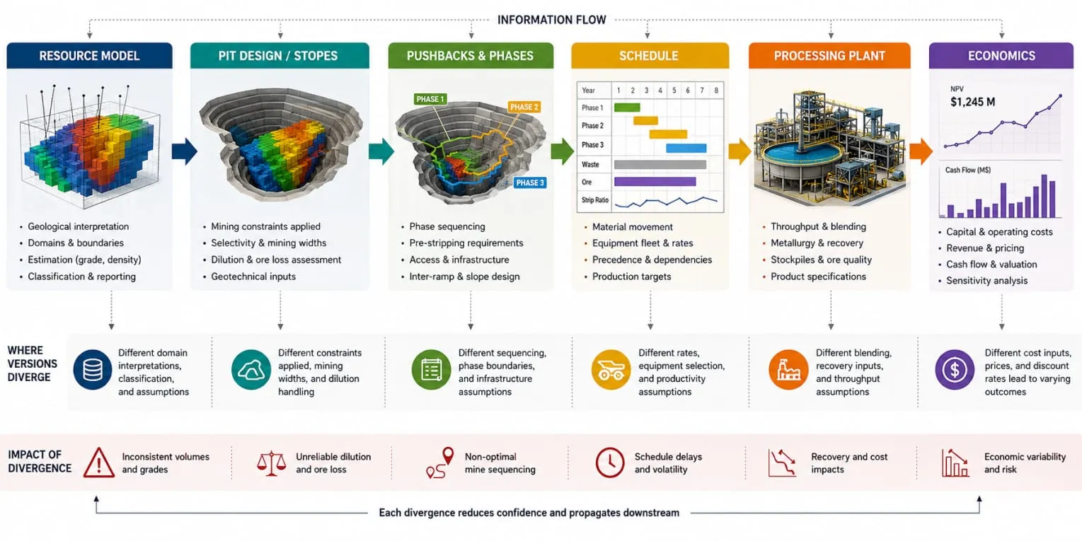
By the PFS or DFS stage, geology, planning, metallurgy, and financial modeling are routinely working from outputs that all trace back to the same resource model, yet have quietly diverged through local assumptions, simplifications, and discipline-specific adjustments. The block model still serves as the common reference point on paper. In day-to-day work, each team is already maintaining its own slightly different version of it.
Mine Planning Is Where Data Starts Losing Operational Meaning
Once the resource model moves into mine planning, the workflow becomes significantly more sensitive to fragmentation. Exploration and estimation can tolerate a certain amount of interpretive flexibility because the main objective is still understanding the deposit. Mine planning is different. At this stage, the project must convert geological information into extraction logic capable of surviving operational, economic, and scheduling constraints simultaneously.
That transition sounds straightforward in theory. In practice, this is where mining projects often begin accumulating invisible engineering friction.
Part of the problem is that planning workflows almost always require simplification. Resource models are rarely transferred downstream exactly as they were built during estimation. Planning teams need practical mining units, cleaner geometries, manageable phase structures, and scheduling logic that can function efficiently at mine scale. Sub-blocking may be reduced, local geological variability may be averaged, and certain attributes may disappear entirely because preserving every layer of complexity becomes operationally unrealistic.
The issue is not that simplification occurs. The problem is that geological context disappears faster than teams realize.
A planner may inherit tonnes and grades without fully preserving the geological assumptions that generated them. Mining shapes become cleaner, but also less connected to the variability that originally existed inside the block model. Destination logic becomes more generalized. Dilution assumptions are often adjusted independently during design and scheduling. By the time production sequences are generated, parts of the original geological behavior have already been filtered through operational assumptions.
Open Pit and Underground, Same Root Problem
This becomes particularly visible during phase and pushback development in open-pit operations. Early optimization shells may align reasonably well with the resource model, but practical mining phases rarely remain that clean once access geometry, ramp placement, working room requirements, waste movement, geotechnical constraints, and equipment limitations are introduced. Engineering teams modify shapes for operational reasons while the geological assumptions beneath them remain partially unchanged.
As a result, the project slowly drifts into a hybrid state where geology, design, and scheduling remain technically connected but are no longer perfectly aligned.
Underground operations face a different version of the same problem. Stope layouts may initially reflect geological continuity well, yet practical extraction sequencing introduces ventilation requirements, development priorities, fill timing, equipment movement constraints, and geotechnical considerations that gradually reshape mining logic. Over time, operational practicality begins influencing geometry just as strongly as geology itself.
These are normal mining realities, not signs of a broken workflow. Problems emerge when the project loses the ability to trace how and why those adjustments were introduced.
How Version Fragmentation Accelerates
This is where version fragmentation starts accelerating.
A revised geological interpretation triggers updated mining areas. Design teams modify phase geometry locally. Scheduling teams adjust extraction logic to stabilize production targets. Metallurgical assumptions are updated separately to reflect new test work. Financial models receive revised production forecasts that may already contain several layers of engineering adjustments compared with the original resource model.
Every discipline is still technically working on the same deposit. Operationally, they are no longer working on exactly the same one.
The most dangerous part is that this fragmentation rarely appears dramatic in real time. It accumulates slowly through exports, local modifications, spreadsheet adjustments, manually corrected shapes, duplicated datasets, and isolated updates inside different technical groups. Each individual change appears manageable. The problem becomes visible later when teams attempt to reconcile outputs across disciplines and discover that assumptions no longer align cleanly.
Newmont’s Tanami operation in Australia’s Northern Territory illustrates how confusing this can become and how much can be recovered once continuity is restored. Tanami is a narrow, high-grade underground gold operation with significant planned dilution and several datasets running in parallel across the value chain. For years, tonnes and grade variances were difficult to interpret because no one could confidently determine whether fluctuations reflected actual mining performance or simply inconsistent volume definitions between models. The resource model, reserves, mined volumes, and plant feed were each describing slightly different rock. Only after comparisons were rebuilt around a common volume did the picture become clear: tonnes increased and grades declined relative to the resource model, not because the operation was underperforming, but because planned dilution was finally being applied consistently throughout the chain. The signal had always been present. It had simply been buried beneath a geometry mismatch nobody had reconciled.
It is one reason why some feasibility studies appear highly detailed yet remain surprisingly fragile beneath the surface. Projects may contain sophisticated schedules, detailed production forecasts, and complex economic models, and still see relatively small upstream changes trigger disproportionate downstream rework because too much of the workflow depends on consistency maintained manually between departments.
Once that happens, engineering teams spend less time improving the plan itself and more time defending whether the latest version still matches the assumptions behind the previous one.
Metallurgy and Processing Data Usually Become Isolated Too Early
One of the biggest misconceptions in mining studies is that geological modeling, mine planning, and metallurgy naturally converge as projects mature. In reality, metallurgical information often becomes isolated surprisingly early, especially once projects begin moving rapidly toward PEA, PFS, or DFS timelines.
During exploration, metallurgical test work is generally treated as supporting information. Samples are selected, variability programs begin, recovery assumptions are tested, and the project gradually builds an understanding of how the ore may behave during processing. At this stage, the relationship between geology and metallurgy remains relatively direct because technical teams are working closely around limited datasets.
The disconnect begins once the project scales.
As drilling expands and resource estimation accelerates, geological and planning workflows become far more spatially detailed than metallurgical datasets themselves. Resource models evolve continuously, while metallurgical understanding develops through a much smaller number of composites, variability samples, and staged testing campaigns. Geology begins moving faster than metallurgy can realistically follow.
Averaging Erases Local Variability
To compensate, projects often average processing assumptions across larger portions of the orebody.
From a study perspective, this is understandable because early-stage economics require stable assumptions and manageable workflows. The problem is that averaging removes precisely the type of local variability that later creates operational difficulties.
A deposit may contain zones with significantly different hardness, recovery behavior, reagent consumption, contaminant levels, grindability, or concentrate quality. Yet by the time these variables reach planning and scheduling environments, they are often reduced to broad recovery factors or generalized processing assumptions assigned to large mining areas.
At that point, the project still technically contains metallurgy, but operationally much of the geological context behind it has already weakened.
This becomes especially problematic once production schedules begin interacting with plant performance assumptions. A schedule may look strong from a mining perspective, maintaining tonnes, stripping ratios, and average grade targets across periods. However, if underlying ore variability has been smoothed too aggressively upstream, the processing plant may later experience highly inconsistent feed behavior that was never fully visible during study work.
This also explains why some projects reconcile reasonably well on tonnes and grade while still underperforming operationally at the plant.
The issue is not necessarily incorrect metallurgy. More often, metallurgical behavior was never integrated deeply enough, spatially or operationally, into the mine planning workflow itself.
The same problem appears in destination logic. In theory, modern mine planning should allow operations to respond dynamically to ore quality, processing limitations, blending requirements, and recovery optimization. In practice, many workflows still rely on simplified destination assumptions because maintaining close integration between geology, metallurgy, and scheduling becomes increasingly difficult once datasets begin fragmenting across departments.
Over time, planning teams compensate manually. Certain ore zones are flagged locally. Processing assumptions are adjusted in spreadsheets. Blending constraints are introduced separately during scheduling. Metallurgical limitations evolve into operational rules instead of remaining fully connected geological variables.
This is another form of information degradation that rarely becomes visible in final feasibility documents. A DFS may still present a coherent processing strategy, stable recoveries, and defensible production forecasts. Beneath the surface, however, parts of the workflow may already depend heavily on manually maintained assumptions rather than continuously connected technical logic.
The Consequences Surface at the Plant
The operational consequences usually appear later, when the mine begins feeding real material into the plant.
Ore variability becomes harder to predict than expected. Recovery stability declines during certain mining periods. Blending flexibility becomes more limited. Some ore zones perform differently from what study assumptions suggested. At that stage, teams often describe the problem as reconciliation risk or operational complexity, when in reality much of it originated earlier through the gradual separation of geological, metallurgical, and scheduling workflows.
That separation is difficult to detect during study work because feasibility models are designed to create stability. Real operations expose variability much more aggressively than spreadsheets do.
Infrastructure, Geotechnics, and Hydrogeology Often Evolve on Separate Timelines
As mining projects mature, the number of technical disciplines expands rapidly. Geology, resource estimation, mine planning, metallurgy, geotechnics, hydrogeology, infrastructure, environmental studies, and economics all begin contributing critical assumptions to the same project. On paper, these disciplines appear tightly integrated. In reality, they often evolve on different timelines and under very different update cycles.
That difference creates another layer of workflow fragmentation.
Geological models may change after every drilling campaign. Geotechnical parameters often evolve more slowly because they depend on structural logging, laboratory testing, and slope stability analysis. Hydrogeological models can change dramatically after additional pumping tests or groundwater monitoring programs. Infrastructure layouts may be revised repeatedly as mine designs mature. Meanwhile, financial models are usually updated only periodically to support study milestones and reporting requirements.
All of these systems influence one another, yet they rarely evolve simultaneously.
As a result, many projects gradually enter a state where each discipline is technically correct within its own scope, while the project as a whole becomes increasingly difficult to synchronize.
When Updates Arrive Out of Sync
For example, a revised pit shell may affect waste dump locations, which in turn changes haulage distances and infrastructure layouts. A geotechnical update may require flatter slope angles, altering mining phases and stripping ratios. New groundwater information can influence dewatering requirements, ramp placement, pumping infrastructure, and operating costs. Environmental constraints may shift waste storage boundaries or delay access to certain mining areas.
Each change is manageable individually.
The challenge appears when updates occur asynchronously.
A planning team may optimize schedules based on one set of geotechnical assumptions while infrastructure designs still reflect older layouts. Hydrogeological constraints may be updated later, forcing redesign work that affects both mining sequences and economics. Financial models may continue using previous operating assumptions until the next study revision, creating temporary inconsistencies between engineering and economics.
None of these discrepancies necessarily represent mistakes. They simply reflect the reality that multidisciplinary projects rarely move at the same speed.
Tools and Org Charts Reinforce the Silos
The difficulty is that mining software and organizational structures often reinforce these separations. Geologists work inside geological modeling environments. Geotechnical engineers maintain their own datasets and software. Hydrogeologists operate through separate models. Infrastructure teams manage designs independently. Schedulers maintain production scenarios. Economists work with spreadsheets and financial models.
The interfaces between these disciplines frequently depend on exports, manually maintained assumptions, and periodic meetings rather than continuous technical connectivity.
As projects become larger, the amount of information moving between departments increases exponentially, while the ability of individuals to track every assumption decreases.
Large-scale operations have repeatedly demonstrated how costly these disconnects can become. At Bingham Canyon, slope stability concerns ultimately forced one of the most significant wall failures in modern mining history. The 2013 landslide moved approximately 165 million tonnes of material. Importantly, the event did not occur because geotechnical monitoring failed completely. In fact, extensive monitoring systems detected instability well in advance, allowing personnel and equipment to be evacuated safely. The challenge was that geological complexity, structural behavior, slope movement, and operational constraints interacted across multiple systems that required continuous interpretation rather than isolated analysis. The technical problem was multidimensional.
Modern mines increasingly face similar challenges, even when failures are far less dramatic.
Ground conditions influence schedules. Schedules influence infrastructure. Infrastructure influences haulage efficiency. Water affects geotechnics. Geotechnics affect ultimate pit geometry. Geometry influences economics. Economics influence cut-off strategies, which feed back into geology and reserves.
Every discipline is connected.
Yet many workflows still treat them as loosely linked sequences instead of continuously interacting systems.
This is one reason why engineering studies often require so many iterations. Teams are not simply refining one model. They are attempting to synchronize several models that naturally evolve at different speeds.
Without strong workflow continuity, the burden shifts from systems to people. Specialists spend increasing amounts of time explaining assumptions, checking compatibility, validating exports, and rebuilding confidence between disciplines.
The larger the project becomes, the harder that approach scales.
Reconciliation Problems Usually Begin Long Before Production Starts
Most mining professionals associate reconciliation with operating mines. Variances between model grades and plant performance, differences between predicted and mined tonnes, and discrepancies between resource estimates and production results are often viewed as challenges that emerge after extraction begins.
In reality, reconciliation problems frequently start much earlier.
By the time a project reaches production, many of the assumptions that drive reconciliation outcomes have already passed through years of interpretation changes, model simplifications, software transfers, and discipline-specific adjustments. Operations merely expose differences that have been accumulating quietly throughout the study stages.
The first disconnect often appears between exploration data and resource estimation. The second emerges when the resource model is converted into mineable shapes. Additional differences enter during phase development, scheduling, dilution assumptions, metallurgical forecasting, stockpile management, and destination logic. Every transition introduces another opportunity for divergence.
Most of these differences remain invisible while projects exist primarily inside study documents.
Production changes that.
What Production Finally Exposes
Once real ore starts moving, uncertainty becomes measurable. Tonnes can be weighed. Grades can be sampled. Recoveries can be calculated. Actual mining widths, dilution behavior, and equipment performance replace theoretical assumptions. What previously existed as engineering scenarios suddenly becomes operational reality.
And operational reality is rarely as smooth as study models.
The problem is not that models are wrong. Models are simplifications by definition. The problem arises when teams lose the ability to trace where and why differences originate.
A grade variance might result from local geological complexity. It might reflect mining dilution. It could stem from stockpile mixing, sampling bias, density assumptions, recovery factors, or scheduling decisions made years earlier. Without continuity throughout the workflow, identifying root causes becomes increasingly difficult because multiple layers of interpretation have already accumulated.
As a result, reconciliation often turns into an exercise in comparing outputs rather than understanding systems.
Teams examine tonnes, grades, recoveries, and production reports, but the underlying assumptions connecting those numbers have already fragmented across departments and time periods.
Some operations spend years trying to solve what appear to be production problems, when many of the causes actually originated during study work.
Reconciliation Belongs Upstream
This explains why mature mines often invest heavily in mine-to-mill reconciliation programs. The goal is not merely to compare forecasts with actual performance. It is to rebuild continuity across geology, planning, operations, processing, and accounting so that deviations can be understood rather than simply measured.
Without that continuity, reconciliation becomes reactive. Teams chase variances after they appear instead of understanding how assumptions propagated through the value chain.
The irony is that reconciliation should not begin with production.
It should begin when the first drillhole enters the database.
Why Workflow Continuity Is Becoming a Strategic Advantage
Mining projects are becoming more complex, not less. Deposits are deeper, ore bodies are more variable, environmental requirements are expanding, and economic pressures are increasing. At the same time, technical disciplines are becoming more specialized, generating larger datasets and relying on increasingly sophisticated software.
None of these trends are temporary.
As complexity grows, the ability to preserve continuity between datasets, assumptions, and disciplines becomes more valuable than individual model accuracy alone.
Failures Come From Broken Relationships
Most technical failures do not occur because one department produces poor work. Geologists, planners, metallurgists, geotechnical engineers, hydrogeologists, and economists are all solving highly specialized problems correctly within their own domains. Difficulties arise when those solutions stop evolving together.
A project can contain excellent geology, robust resource estimation, sophisticated mine planning, sound metallurgy, and detailed financial analysis, yet still struggle because the relationships between those components have weakened over time.
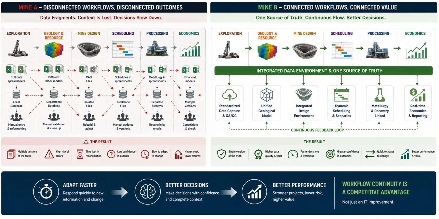
This is why workflow continuity is increasingly becoming a strategic advantage rather than merely a software issue.
Continuity preserves context.
It allows geological assumptions to remain visible inside planning. It keeps metallurgical behavior connected to scheduling decisions. It helps infrastructure evolve alongside mine designs. It enables reconciliation to trace deviations back to their origin instead of merely reporting them after the fact.
Most importantly, continuity reduces dependence on institutional memory.
Mining projects often span decades. Personnel change, contractors rotate, ownership structures evolve, and study teams expand. Information that exists only in spreadsheets, local files, email threads, or the memory of experienced individuals becomes progressively more fragile with time.
Systems that preserve relationships between data are inherently more resilient than systems that rely on people remembering why decisions were made.
Continuity Is the Prerequisite for Digital Mining
That resilience is becoming increasingly important as digital transformation accelerates across the industry. Artificial intelligence, automation, digital twins, and advanced analytics all depend on one prerequisite: trustworthy continuity between datasets.
Disconnected workflows do not become smarter simply because more technology is added. In many cases, complexity amplifies existing fragmentation.
The mines that gain the most value from digital tools will not necessarily be those with the largest datasets or the most sophisticated algorithms. They will be the operations capable of maintaining traceability and consistency across geology, engineering, processing, and production over time.
In other words, competitive advantage may depend less on how much information a company possesses and more on how well that information remains connected.
Because in mining, value is not lost only through dilution, recovery, or operational inefficiency.
Sometimes it disappears quietly between workflows.